The Front Range of Waterton - Mount Crandell
Distance: 12 km / 7.45 mi (round trip)
Time: 6 to 8 hours (plan a full day)
Elevation Gain: 1040 m / 3412 ft
Download a .gpx file of our hike here. Just click the link and download and extract the Zip file: mount_crandell.zip

|
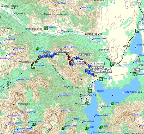
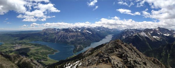
It was a great day to hike Mount Crandell. There were seven hikers including my two sons, ages 17 and 19, the other five being an assortment of old geezers. The trailhead starts at the Crandell Lake Trailhead off the Akimina Parkway. It’s a short distance up to the ridge, (.8 of a kilometer, or 1/2 mile). Once you hit the sign (see Picture #2) you take the single track bicycle trail a very short distance. You will find an obscure trail to your left or north side heading up the mountain. The trail fades in and out but the general direction is to stay on the south ridge and head up the mountain – no set way, and no tricks – all ways lead up. The two boys ditched the old guys early and headed straight up the more west ridge which is steeper. It had been a number of years since I have climbed Mt. Crandell and I was taken by the stunning views of both the Akimina Parkway/Crandell-Cameron Lake Valley and the Red Rock Canyon Valley. This is one of the most spectacular ridge walks, giving a beautiful view of what Waterton is all about. There is no better mountain to peak than Mount Crandell for the panoramic view of Waterton and surrounding area. |

|
|
|
|

Take the turn down the Waterton townsite path. Shortly after taking it your path up will be on the left. It's hard to spot, looks only like a game trail but once you're on it the way becomes clear. |

Hiking up the South slope of Mount Crandell and looking back at the Akamina Parkway. |
|
|
|

Walking up the South slope of Mount Crandell, not too difficult. |

South slope of Mount Crandell |
|
|
|

|

Crandell Lake from the south slope of Mt. Crandell, with Akamina Parkway to the left (South). |
|
|
|

Walking up the South stream. There are numerous ways to go up, this rock outcrop goes straight up and is easy going scree. |

|
|
|
|

Final summit to the first Peak. |
 As you near the top of the first peak you can see the Waterton Lake. |
|
|
|

It took the younger boys one hour and twenty minutes to get to the first peak, they were asleep up top waiting for the rest of us, for whom it took two hours. |
|
|
|
|

Once up it is easy to see the long skyline ridge one takes to the actual summit. |

Wild flowers were out in great abundance and we were able to take some pictures right on the very top. The ridge walk was beautiful, although a bit windy at times. Be prepared for this. |
|
|
|

From the first summit this panoramic image shows the nice easy ridge walk up to the true summit on the right. Red Rock Valley can be seen on the left side of the image. |
|
|
|
|

Looking back at where we had walked after about the half way mark. |

Looking South to the final summit. |
|
|
|

The half way mark heading towards the final summit. There is not that much elevation from the first peak to the actual summit. |

Towards the end there is a slight hill and you will ultimately hit the satellite tower with the helicopter pad. |
|
|
|

At the top you can see the panoramic view all the way down the ridge to Bears Hump (an alternative route and potentially the most technical). In the distance you can see Alderson Lake and Mount Alderson. |

View from the weather station and helicopter pad. |
|
|
|

Old Chief Mountain has a very different look from the east side! |

Just below the weather station is this short ridge which can give you an expansive view of the Lakes & Waterton townsite. |
|
|
|

Great views from the Southern ridge just below the weather station. If you carry on down this ridge the going will get quite technical and you will end up at the Bear's Hump. |
|
|
|
|

Tick Ridge can be seen going down to the left. Tick Ridge is one of the common ways up and down Mount Crandell. |

We however are going to be taking the next ridge to the North of Tick Ridge. From the weather station we head slightly back on the path we came up but stick to the North and East. |
|
|
|

On the North Shoulder of Mount Crandell. Tick Ridge is the dark ridge on the right side of the image. From here we stay on the ridge to the left. |

Some of the best views of the Waterton townsite can be seen from this North ridge. |
|
|
|

Before the end of the North Ridge you need to start heading South down into the gully. If you continue on the North Ridge it may offer some good views, but it will become evident that it's not the way to continue. |

Heading down into the gully is the most technical part of this hike. |

Taking a short rest on the way down! |
|
|
|
|

You will ultimately arrive at a small creek that is dry most of the year. The best way down from there is to head west or to the right hand side of the dry creek bed and stay as far right as you can. You will ultimately pick up a trail which is quite well defined and then head straight to Crandell Creek. |
|
|
|
|

You take Crandell Creek until you see the old road with the rocks blocking off the old road. The entire trip took us approximately 6 ½ hours and it was 10 kilometers (or 6.1 miles). Keep on hiking. Lockey. |
|